Porcupine Mountains Wilderness State Park

Porcupine Mountains Wilderness State Park
Outstanding outdoor opportunities in pristine woods.
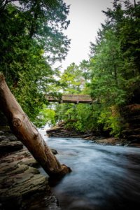
Porcupine Mountains Wilderness State Park is 15 miles west of Ontonagon in Michigan’s Upper Peninsula. The park’s 60,000 acres are one of the few remaining large wilderness areas in the Midwest. Towering virgin timber, secluded lakes, and miles of wild rivers and streams make a visit to the “Porkies” a trip to remember.
 The Porcupine Mountains Wilderness State Park was established in 1945 by Michigan’s Legislature. Since then, many changes have taken place in the way we live; however, the Porcupine Mountains are almost unchanged. The remote interior with its towering pine and hemlock seems to defy time. The solitude of the park is mysterious and exciting.
For information on waterfalls in the area, download the “Find Your North Waterfall Guide“.
Under the Radar – Porcupine Mountains
Under the Radar, which is a Michigan’ Public Television show visited the Porkies for an incredible experience. Watch the show below.
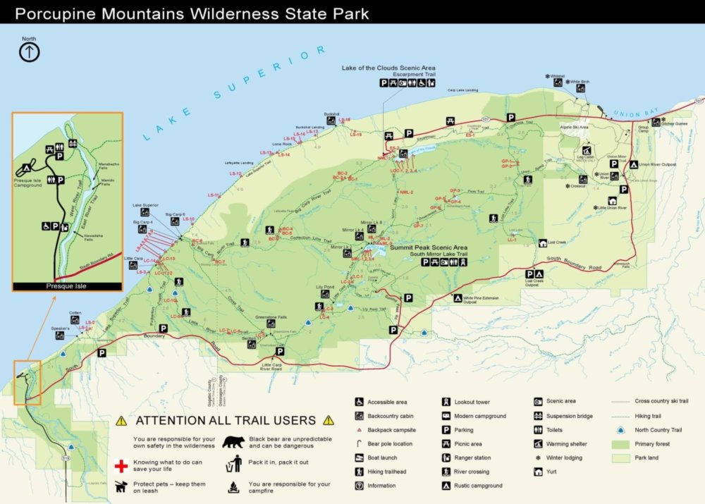
Park Map
Click here to download a full map of the park.
Michigan DNR
Click here to visit their website to book your trip.
Click here for more park details from the DNR.
Presque Isle State Park Campground & River
The Porcupine Mountains Presque Isle Campground offers 50 rustic campsites near the scenic Presque Isle River. There are vault toilets and hand pumps for water. In addition to drive-up sites, there are also 6 walk-in sites.
The campground is split into two loops. The east loop is a generator friendly side, while the west loop is generator free.
There is access trails to the nearby Presque Isle River and or to the Lake Superior shoreline. Firewood is available for purchase at the campground office.
At roughly 60,000 acres, Porcupine Mountains Wilderness State Park is Michigan’s largest state park. It is home to 35,000 acre old-growth forest, roaring waterfalls, miles of rivers and streams, more than 90 miles of hiking trails, the Lake Superior shoreline and vistas unrivaled anywhere in the Midwest.
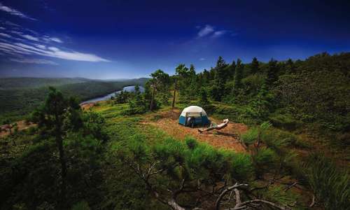
Backcountry Camping
![]() The North Country Trail hiking trail, which spans from North Dakota to Vermont cuts right through the park and acts like the backbone running west to east. Do some backcountry camping and find yourself in very remote wilderness.
The North Country Trail hiking trail, which spans from North Dakota to Vermont cuts right through the park and acts like the backbone running west to east. Do some backcountry camping and find yourself in very remote wilderness.
Click here for back-country camping registration.
The Porkies – Downhill Ski Hill

Snowshoeing opportunities are abound in Ontonagon County with thousands of acres of snow covered back country wilderness to explore. Long a popular winter activity in the Upper Peninsula, visitors are finding snowshoeing an excellent way to enjoy winter’s splendor in Ontonagon County.
Lantern Lit Snowshoeing, Cross Country Skiing, Four main and several smaller trails combine to form our 42 KM Nordic Trail System. The trails feature two warming shelters. Trail Map
In addition, Lake of the Clouds can be reached by following M-107, which is unplowed in winter.
*All XC-Ski trails maintained and operated by MI DNR. For detailed trail conditions call 906-885-5275*
For snowmobilers, Lake of the Clouds can be reached by following M-107 which is unplowed in the winter. Ontonagon County’s 350 miles of groomed, marked snowmobile trails pass through some of the finest scenery in the Midwest. Travel through the deer yards and woodlands of the Ottawa National Forest.
For snowmobilers, Lake of the Clouds can be reached by following M-107 which is unplowed in the winter. Ontonagon County’s 350 miles of groomed, marked snowmobile trails pass through some of the finest scenery in the Midwest. Travel through the deer yards and woodlands of the Ottawa National Forest.
Park GPS & GPX Coordinates
Click here to see park GPS & GPX Coordinates for the Porcupine Mountains Wilderness State Park.